CLICK for RSS feed here

Tuesday, December 29, 2020

Malawi’s Market Mamas and Papas – Why neither lockdown nor herd immunity is an option


On April 2, 2020, three weeks after declaring a nation-wide state of emergency and well behind the reporting curve elsewhere, Malawi’s government publicly reported the country’s first cases of the coronavirus disease (COVID-19).  Within that first week, 16 confirmed cases and two deaths were attributed to COVID-19.  In the last week of December 2020, the rate of weekly infection was running at a reported 193 new cases, adding to the now total 6,377 people infected and 188 deaths although, as in so many countries, the full number of infections and deaths from the coronavirus disease will probably never be known, in part because of low testing rates.  But the ongoing rate of infection has been concerning enough that on December 23, 2020, the authorities announced a 14-day closure of the landlocked country’s international borders although shying away from an internal lockdown. The move recognizes the importance of restricting connectivity and travel in containing or circuit-breaking the spread of the disease, and borne out by several recent urban planning studies that weigh the impacts of urban density and connectivity in transmission.

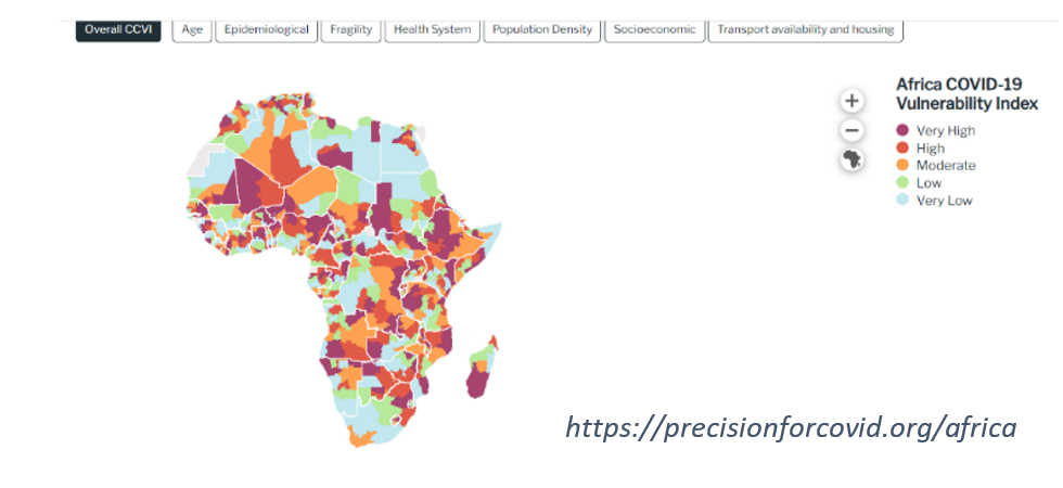
Malawi does not make it into the international news very often.  A landlocked country in Central Africa, it is known, if at all, through its tourism byline as “the warm heart of Africa”.  But compounding the alarming coronavirus news is that festering behind the warmth and friendliness shown to all travelers, is a people smitten by one of the highest poverty rates in the world and a history of poor governance that have meant little progress in addressing poverty and inequality over the past decades.  And whilst a child born today might have a three-times greater chance of surviving to the age of five and a 17% higher probability of finishing primary school than if they had been born 15 years ago, GNI per capita remains an impossibly meagre US$380/year.  Nearly three out of four Malawians somehow subsist on less than US$1.90 per day – insufficient to meet a basic daily calorie intake.  In a country that is only 17 percent urbanized, rain-fed agriculture and fishing-based livelihoods are routinely afflicted by insect plagues and weather shocks such as droughts and floods which have been noticeably increasing in intensity and frequency due to climate change.

Add to this that Malawi and its neighboring countries lie along the north-south trucking corridors through Africa and have faced a multi-decades long HIV/AIDS epidemic.  By mid-2006, WHO was reporting HIV/AIDS as the leading cause of death in the region amongst the productive age groups. Today, around 70 percent of people in the world living with the disease are in Sub Saharan Africa.  One in ten adults in Malawi are infected and the country has anywhere between 500,000 (WHO) to two million orphans and vulnerable children directly related the AIDS epidemic (see Paul Mkandawire’s thoughtful “Vulnerability of HIV/AIDS orphans to floods in Malawi”).  As so poignantly documented (in Kenya) in Andrew Tkach’s and Christiane Amanpour’s Where have all the parents gone?, deaths and the reduced ability for physical labor amongst working-age people further impoverishes families.  Generations of grandparents are now having to work longer hours and shoulder the ongoing obligations of family breadwinner, care-giver and child-carer.

The ‘fifth-risk’ – the risk of an international viral outbreak that had been worried about by some but ignored by most, has swept across the globe in 2020.  In less than four months, it had touched every country on the planet.  Now, in December 2020, and after close to a year of the world learning to live with the coronavirus pandemic, we have all become armchair epidemiologists, but it is only the most perverse who continue to maintain that livelihoods vs. health is a binary choice.  So, back in April 2020, when Malawi’s then ‘Tipp-ex President’ Mutharika announced a mandatory 21-day nationwide total lockdown that would close food markets and non-essential businesses, restrict hours for (outdoor) farming, and only allow health and emergency services workers to use public transport, it was not unsurprising to hear on international news stations that Malawi’s market vendors in Blantyre and Mzuzu were angrily protesting in the streets and that they had joined forces with the Human Rights Defenders Coalition to successfully challenge the lockdown order in court.  Similar news stories of dramatically enforced total lockdowns have emerged from cities across the Global South from India to South Africa to Nigeria, highlighting the plight of informal and casual workers who form the majority of many of the countries’ workforces and who, even under pre-pandemic circumstances, faced daily food shortages and lived from hand to mouth with no buffer to weather shocks.  

The strongest health advocates recognize that in countries and parts of countries where the populations are largely ignored by their governments, calls for lockdowns are nothing more than political virtue-signaling by politicians if they are not accompanied by equal or greater commitment to roll out testing/ tracing/ containment (a.k.a. quarantine, self-isolation) protocols, ramp up woefully under-resourced health treatment facilities with additional adequately protected staff, and provide basic services and  income support for those most affected by the restrictions.  In short, lockdowns are a measure intended to buy time where basic preventative measures (social distancing, mask wearing and where possible, regular hand washing) have not been achieved and until mass vaccinations are possible.    

Throughout 2020, many countries – rich or poor, democratic or centrally planned, large or small, led by women or men, and densely or less densely settled have cautiously and responsibly managed to find a balanced approach to protecting lives whilst at the same time stimulating lower risk economic activities and providing profligate support to affected and vulnerable groups.  Countries such as Australia, New Zealand, Singapore, South Korea, Japan, Vietnam, Germany, Finland, Norway, Vanuatu, Samoa, Kiribati, and many more will have lessons for all of us in the years to come, including of governments communicating clear and unambiguous health messages and providing equitable basic services and economic support measures, and of citizens being concerned for and helping their own families and neighbors.  For every crazy that this year has thrown up, there have been countless examples of resilience in action where countries, communities and individuals have embraced measures “ to effectively manage their own layer of risk”.

At the time of writing this blogpost (December 2020), several countries - including wealthier ones with less enviable records of COVID-19 management, are developing policies and commencing vaccine delivery for  healthcare and essential workers, vulnerable groups and the elderly.  Populations are eagerly anticipating that safe and effective vaccines can be rolled out, for free, to those that want them over the coming weeks and months and in the hope that by mid-2021, life for people living in these countries might “return to normal”.  We also know - but do not speak enough about, that vaccination roll out will be a logistical nightmare and will require recruitment and multi-year funding for huge numbers of trained health workers to administer the cold-stored vaccines.  Widespread vaccinations in countries with the least buffers (including most of Sub Saharan Africa and South Asia) are unlikely to be available any time before 2024, even if funding were assured through the COVAX alliance (which it is not).


Tinkering with one of the online  models or browsing the Surgo Foundation’s comprehensive COVID Community Vulnerability Index (aboveone gets a chilling picture of the numbers of people in the world’s poorer regions who are at almost inevitable risk of becoming seriously ill and or dying from the coronavirus disease before vaccinations reach them.  The Food and Agriculture Organization has estimated  that the number of undernourished people has increased by up to 132 million people in 2020 due to the pandemic. The World Bank predicts that extreme poverty is rising for the first time in 20 years and that the pandemic is pushing between 88-115 million people into ‘extreme poverty’ (less than US$1.90/day) and doubling the number of ‘new poor’ (less than US$3.20 per day).  In fact, losses in well-being are being felt against all metrics and even worse than predictions that were being made by the OECD less than six months ago (see below).   Along with growing inequality within and between countries, this also raises the potential for civil unrest and armed conflict.
This should worry all of us.  As a world, we are no closer to resolving the 2,400-year-old ethical dilemma captured in Plato’s Gorgias dialogue between Callicles and Socrates.  As wealthier societies debate their Calliclean "natural right" to be first in line for COVID-19 vaccines versus the tempered Socratic view that we would all be better off ensuring that everyone, everywhere had the same right to return to a pre-pandemic normal as soon as possible, the urban poor - as exemplified by Malawi’s Market Mamas and Papas, are not waiting for outside help.  Everywhere, very simple but effective measures of making and wearing masks (see pattern), contact tracing and messaging, and (where possible) handwashing are in use.  Urban planners, myself included, are digging through long shelved lessons on how to more efficiently deliver basic services such as water and sanitation, prepare more strategic guided city expansion plans, and scale-up affordable, well-located sites and services new subdivisions, and cheap and efficient transportation services to accommodate the expansion rather than continual containment and densification that in turn has forced unplanned, unserviced sprawl of rapidly growing cities.

Are there limits to what can or should be expected and will the impacts of COVID-19 be one burden too many for some communities and families? The question of how to respond to the world’s urban and rural poor is not a question of if, it is rather a question of will each of us, and how?  As we excitedly await vaccine rollout over the coming months, let’s spare a thought and possibly even some charity for those who may only receive vaccinations sometime around 2024 and may otherwise buckle before then. 

    Photo credit: https://www.imvelosafarilodges.com/hwange-needs-you.html


Monday, February 17, 2020

Addressing the urban poor | Part 4: The choice is ours - disruptive or disrupting?


This is the 4th in a four-part blog. You may want to skim through Parts 1, 2 and 3 before continuing ... 

The technologies of high-resolution satellite imagery, machine learning and large-scale data capture and storage are converging at a rapid rate.  Inevitably, the relevance of manual addressing systems is diminishing.  Providing accurate geocoded addresses – either as precise points or GIS-ready building footprint polygons to the half to three-quarters of humanity who do not live around distinctive street patterns or have accurate addresses is now a very real technical possibility and being made probable through commercial applications.  All of built Australia – comprising 15,243,669 buildings located over the continental expanse of 7.6 million km2, has been captured by PSMA Geoscape which also plans to release updated datasets for at least 5,000km2 of urban and remote community areas every year going forward.  DigitalGlobe is working on a building footprints dataset for the US and possibly internationally.  Researchers from Facebook Connectivity Lab and MIT Media Lab have developed an algorithm (RoboCode) that uses deep learning to recognize roads from satellite imagery, and, after partitioning the road network into neighborhoods, goes on to label regions, roads, and blocks using proximity-based algorithms.  The method is more akin to our familiar street addressing systems than the geocoding systems based on latitude and longitude coordinates although, arguably, the unique addresses – such as “715D.NE127.Dhule.MhIn”, remain awkwardly unintuitive.  Results on RoboCode published to date include that human settlement maps covering 20 countries in Africa have been generated: inside of two weeks and at a spatial resolution of 5 meters which improves previous manually prepared countrywide data sets by multiple orders of magnitude, although the results still need ground-truthing (verification) in the field. Most recently, a partnership of Bing Maps, the community of Humanitarian OpenStreetMap Team (HOT) and Microsoft Philanthropies has created building footprint open datasets covering Uganda and Tanzania for OpenStreetMap users.

I personally believe that it is important that cloud-stored and possibly open-source available datasets of where and how I live are matched by equally robust data privacy and data protection principles, including, where appropriate, with my knowledge or consent of where and how my data is being used.  Whilst exhilarating technologies now allow us to map the world and in time, geolocate every person on it and store all their details, there is risk that the parameters and limits on public use of this personal information are being left behind.  The risk is compounded in that many of the agencies and staff involved in addressing and collecting sometimes deeply personal information for ‘development purposes’ do not always encrypt and adequately protect that information and openly distribute it by e-mails, memory sticks, etc. In part, this may be because managers and staff themselves are not particularly tech savvy.  Awareness of the need for anonymizing  shared data and developing systems and staff capabilities to do so is clearly an area needing greater attention and resources.

But for me, the most powerful lesson in addressing was one that I learnt many years ago in Epworth (even though using what today would be archaic technology!)  In the face of today’s exciting, disruptive technologies we shouldn’t lose sight of the fact that sitting behind any three words/plus code/ geo-coded or labelled point or polygon on an e-map are fundamental data that identify and record who has the right to use, manage, transact with other parties, withdraw or transfer that physical space, and the rights and responsibilities of the wider community around that space.  Property rights are not exogenous.  In every country, these rights and responsibilities have emerged and continuously develop over time.  Owner- or user-rights are a function of push-pull economic, social and political forces, and levels of societal and government enforcement that evolve in different ways in different countries  and over generations of time.  In a deeply esoteric way, addresses are a form of social compact between authorities and residents.  As such, addresses are only of utility in poor neighborhoods if they certify to a wider recognition of what UN-Habitat has recently branded “the right to the city” by the addressee.  A geo-coded or algorithm-generated spatial address is of limited use and, in some circumstances and in the wrong hands, could prove to be harmful to the urban poor (for example, by identifying them for eviction) if it is not subordinated to a ‘pink slip’.  For this to happen, the massive power of evolving technologies that is being driven by suppliers might be more effective (and ward off concerns of the potential to do harm) if it were linked with and paced according to invitations by communities wanting those addresses.  And the resources being invested in developing spatially accurate address labels need to be matched by equally strong efforts aimed at resolving and negotiating ‘pink slips’ - the right to live in that place, for all urban residents, including the poor.  Ideally, addresses should be available to everyone – but perhaps we need to roll them out at - rather than three, only one word at a time.   
Household head agreeing with community worker on the placement of her address, Tebikenikora, Kiribati
(Credit: C. Butcher-Gollach, December 15, 2017)


Addressing the Urban Poor | Part 3: Using disruptive technology in Kiribati, Pacific Islands


This is the 3rd in a four-part blog. You may want to skim through "Part 1: What's so important about an address?" and Part 2: Addressing the hard way (manually) in Epworth, Zimbabwe" before continuing ... 

Fast forward to 2017, to a pilot water improvement component under the World Bank-supported Kiribati Adaptation Program Phase III (KAP III).  Kiribati comprises 32 low atolls and a raised coral island scattered over 3.5m km2 in the center of the Pacific Ocean.  This nano-country’s 110,110 people live on 21 of the atolls, most of which are less than 2 km wide and are no more than 6 m above sea level at their highest points.   About half of Kiribati's population lives in the main town of South Tarawa, in largely unplanned and critically under-serviced urban ‘villages’.  Living conditions in many of these urban villages are as challenging as can be found in the slums of much larger, rapidly growing cities in the global South, and for the same underlying reasons.  After years of unmanaged and unattended urban growth, policy neglect and lack of investment in new serviced lands, South Tarawa’s residents, and especially the middle- and low-income groups, face an across the board lack of even basic lifeline services and have limited housing options other than to crowd into the existing housing stock or self-build on marginal lands.  The result has been a huge public health load of preventable diseases such as infant diarrhea, worm infestations in children, adult pneumonia, and other infectious diseases (“Health and the City: Consequences of the ‘King Tides’ of Urbanization in Kiribati”).  

Payments for any urban services are tied to effective demand of the customers.  In the case of the pilot zones, this was determined as the residents’ ability to pay the new tariffs (based on the water utility’s experience of what would be affordable to residents as there was no recent household income information) and their willingness to pay for the service.  It also became apparent during construction that willingness to pay is tied to not only an improved, engineered water service (reliable, 24/7, pressurized, clean supply) but  to the ease with which one can receive bills, make payments and report faults that need fixing.  Asking someone where they live in Tarawa elicits a response such as "Nanikai airiki " (oceanside) or "Tebikenikora tanrion" (lagoon side) – not particularly useful for delivering a household water bill or for following up on overdue payments or reporting a faulty meter for quick attention.  In December 2017, we met with around 30 local experts – from the Public Utilities Board, Ministry of Lands, National Statistics Office, Kiribati Postal Services and project staff to find an answer to how to provide addresses to nearly 500 houses before the new water supply was turned on.  

Kiribati has various existing land/building registers – the formal Ministry of Lands’ cadaster, the Kiribati Housing Corporation’s list of public housing, and the Public Utility Board’s list of customers and existing water meters.  There is also a somewhat opaque “Me + brothers + sisters” vernacular system in use and the churches keep a list of members and church-owned houses and buildings.  However, none of the systems is up to date or has full coverage, there is no common ‘key’ to easily link and combine or overlay the different systems, and several errors were found when trying to map the underlying data including that several houses appeared as located in the ocean! (See figure below).  

Nanikaai, South Tarawa - mismatch between building footprints as digitized in 
Ministry of Lands’ cadaster, engineering drawings and actual location of existing
water customers prior to KAP III investments. 

(Generated by Gollach using ArcGIS, June 2018)

At first, there was unanimous agreement to a suggestion to use street names and numbers as found in planned cities around the world.  However, as we had found in Epworth all those years ago, it was recognized that it would take months of politically charged discussions to agree on names for existing streets and anyway, in most villages, access ways were footpaths rather than any well-defined hierarchy of roadways.   Our Expert Group recalled that in the 1980s, all houses on South Tarawa had been physically numbered by the authorities.  As with Epworth, it had taken many person-months of time and effort to do this valuable exercise.  Unlike in Epworth, the Tarawa numbering system had not been disaggregated by areas and it did not allow for future infill or new development; the numbers ran from 1 to n in increments of 1 and the system had not been maintained and had not kept up with urban expansion or infill since then.    

Might it be possible to send out teams with GPS handhelds and once again number all the houses in the pilot zones using geographic coordinates?  The net of latitude and longitude has stood up well everywhere across the globe since John Harrison, a self-educated carpenter from humble beginnings, turned his hand to clockmaking and, after many years of effort “wrested the world’s whereabouts from the stars, and locked the secret [of longitude] in a pocket watch”.  There are countless examples internationally of successful community mapping initiatives and the empowerment that self-profiling produces.  Perhaps the communities themselves could be meaningfully engaged in identifying the coordinates for their houses?  However, some worried about the availability and costs of handhelds on the small remote island; others were concerned about the potential for human error and the difficulty for households to accurately remember their address in a GPS format (see example to left).  Nonetheless, an addressing system based on point-based geographic coordinates and using technologies for fast and accurate inputs held promise.


Several coordinate-based, free or open-source addressing systems have emerged recently.  One of the first, GOCode which was born out of community mapping, converts coordinates into easy to remember 7- to 9-character alphanumeric codes, such as “L6G 56LP”.  However, GOCode had limited coverage (India, Ireland, Kenya, Ghana and Ecuador but not Kiribati).  A similar coordinate-based system has recently been developed by Google Plus Codes.  The plus code – available once a point is tagged in Google Maps, consists of 6 or 7 letters and numbers and the town or locality name, for example “VXX5+J2 Washington, District of Columbia, USA”.  Places that are close to each other have similar plus codes which the company states should make it easier to identify addresses that are near each other but might compound human errors when recording the addresses.  At that time, the Plus Codes system wasn’t yet available but does seem worth piloting in unplanned settlements in the future.

We finally settled on a system that the Kiribati Postal Service had signed up to but hadn’t yet been able to put in place, namely “What3Words”.  What3Words runs on a commercial app that can be downloaded and used freely on smartphones which are now ubiquitous even in small and remote countries.  The system divides the world into a 3m X 3m grid.  Every cell (square) across the globe - on land or sea, is given a unique 3-word address.  The company is quick to point out that a similar 3m accuracy using GPS coordinates would require 16 digits per address – both difficult to remember and easily corrupted.  The system can be used both offline (Open Street Maps base) or online (satellite image base).  Counter-intuitively, in a country where English is a second language, we found that the water utility field staff and households easily recorded and remembered addresses such as “unspeakably.dread.gymnasium” rather than the coordinates “1.32995484, 172.9954361”.  After brief training, the What3Words addressing system was accurately and rapidly rolled out at very low cost in the three pilot villages by field staff and a local youth group, providing addresses to 440 houses.  Each handwritten address was proudly taped onto the house by the hitherto unidentifiable household.  The 3m grid meant that different, unique addresses could be provided to separate water meters in multiple occupancy houses.  The words are deliberately random.  This has the disadvantage that unlike a conventional street numbering system, there is no discernible pattern to the addresses and so no resultant ‘sense of place’.  But equally, it ensures that misspellings can be easily identified and corrected in the type-ahead or speak-in functions of the easy-to-use app.  

There were a number of useful lessons we learnt in the field in applying a disruptive technology in the small developing country Kiribati.  Different quality smart phones have different levels of accuracy although most are typically to within a 5m radius under conditions of clear skies. Accuracy was affected by large trees and weather conditions such as approaching thunderstorms.  This, coupled with the small 3m grid meant that even a mid-sized house might have two or more W3W addresses.  We offered the household the choice over which they preferred (and blamed ‘the satellite’ when none of the words was to their liking!)  In the pilot zones, we addressed the household’s water meter whereas the Postal Services prefers to address the main external door.  Either way, the correct house is usually easy to find based on the selected address, even in dense settlements.  

There is a healthy and ongoing debate around whether to use proprietary vs. open source software.   For now, What3Words and Google Plus Codes are free to use and the companies sitting behind the software offer updates and technical support to their users.  What3Words offers plug-ins for interoperability/working in QGIS and ArcGIS and the UN has recently integrated W3W as a geo-referencing system into its disaster reporting app UN-ASIGN to tag photos and damage reports.  When we requested mass use/ batch conversion for more than 25 addresses from geographic coordinates (or vice versa), the company always responded within 12 hours and helpfully allowed us to do so.  As a back up measure to ensure the integrity, independence and permanence of the addressing system, the W3W addresses were entered into the water utility’s records alongside the meter serial number and other customer details together with the underlying geographic coordinates and accompanying maps.  Overall, the addresses in the pilot zones were assigned easily and at very low cost.  We continue to use the system elsewhere in the Pacific Islands and South Asia, for example to assist survey enumerators locate randomly selected households for planning purposes, identify households falling behind on water payments for personalized visits, and for government officers on remote outer islands to create inventories of rainwater tanks and other physical assets. 


This is the end of the 3rd part of this four-part blog. “Part 4: The choice is ours - disruptive or disrupting?" continues below. 


Sunday, February 16, 2020

Addressing the Urban Poor | Part 2: Addressing the hard way (manually) in Epworth, Zimbabwe

This is the 2nd of a four-part blog. You may want to skim through "Part 1: What's so interesting about an address" before continuing ... 

I first became aware of the challenges of providing addresses - and especially for residents in informal settlements, in the 1980-1990s when working as a young, recently graduated urban planner in the Department of Physical Planning, Zimbabwe.  In the euphoric, early years of independence from colonial rule, the government had a pro-poor housing policy and some individual politicians actively encouraged urban land invasions by the rural poor.   However, over time, official hostility towards the unstoppable waves of ‘squatters’ from rural areas who were flooding Zimbabwe’s cities and towns in search of employment and opportunity was on the rise.  A decades-long series of government-coordinated, squatter clearance drives were mounted, with forcible and uncompensated evictions of large numbers of people whom the authorities branded as being “squatters, vagrants and unaccompanied women”.  Tens of thousands of people were expelled from the cities by police and para-military police - armed with assault rifles, shotguns, batons and tear-gas canisters, to holding and ‘re-education’ camps and rural resettlement schemes. (The most notorious holding camp was at Mushumbi Pools in the Zambezi Valley with news media- reports of the displaced urban poor contracting malaria and in at least one case, being eaten by lions).


Porta Farm settlement - before and after demolitions, 2006
(Source: "GeoEye Foundation Satellite Imagery Confirms Human Rights Violations in Porta Farm, Zimbabwe"
https://www.youtube.com/watch?v=2M8InoKxHwE)

Epworth, on the outskirts of Harare, was one of the largest and most socially organized of the first round of  early settlements facing demolition.  The settlement was home to around 63,000 people living on Methodist mission-owned land.  The Epworth residents successfully challenged their eviction orders and obtained a reprieve through the courts on the grounds that they were not squatters because they had proof of having paid land-rents to the mission landowner for many years.  Following lengthy negotiations, an agreement eventually was reached between authorities and residents on the parameters of what would become one of the first attempts at in situ settlement upgrading in Zimbabwe, primarily (from the authorities’ point of view) aimed at containing future expansion of the settlement and safeguarding public health in the surrounding city neighborhoods.  As the government’s Physical Planners responsible for the Epworth area and inspired by the teachings of John F. C. Turner and Robert Fichter (Freedom to Build), a small group of us initiated and set about planning and implementing a very basic settlement planning and services improvement program with the Epworth communities, all on the smell of an oil-rag.  We were shadowed by 12 Local Government Promotion Officers (LGPOs) who described themselves as “the Minister’s eyes and ears” and dutifully monitored and reported on our every action. 


Resident in Epworth, Harare, Zimbabwe.
(Credit: Ephraim Nsingo/IPS;  http://www.ipsnews.net/2009/01/zimbabwe-now-a-39factory-for-poverty39/)
This dramatic concession by the authorities required that every existing shelter and its occupants had to be recorded and as quickly as possible, before there was a change of policy.  A development freeze in Epworth was officially announced.  Any house or shelter that had been built prior to this public announcement was authorized as permanent.  Stern warnings were given that any newcomers after the announced freeze would be summarily evicted.  As there was only one named road throughout the entire 35 square kilometer settlement, a conventional house or lot numbering system based on street names was not possible within the short window of opportunity.  These were days long before satellite imagery was easily available.  We arranged for low altitude, air photography to be flown on a grid pattern across the entire settlement, ortho-rectified and then printed onto paper-based sepia maps (link provided for Millennials!)   In discussion with community leaders, the boundaries of the four main villages as originally laid out by the mission authorities were demarcated, namely Makomo, Muguta, Chinamano and Zinyengere.  Each of the original villages had contiguous ‘extension’ areas where lots were being sold off through informal verbal agreements by the original land renters to newcomers.  As such, our addressing system was simple: Village name, Area code (A = original or B = extension) and House number.  Thus, for example, a house/yard in Muguta Extension might be numbered as “Muguta B/128”.  Each dwelling unit and yard (identified by the main household and agreed by neighbors) was given a number on the printed air photos with allowances made in the numbering system for possible future infill.  We then painted the assigned number onto every house … by house, by house over a period of 3-4 months.    The LGPOs recorded the names and details of residents occupying each numbered house and issued a ‘pink slip’ to the head of household.  

A pink slip certified the existence of the household living at that address - its right to remain in Epworth and its future right to a clean water supply from a shared tube-well fitted with a low cost, manual ‘Blair pump’ and enough materials to build a ventilated improved pit (VIP) toilet.  In other words, fundamental rights to remain in the settlement and to receive basic infrastructure services – all made possible by a strong policy decision (driven in equal part driven by public health and political control considerations) and based on a low cost, low-tech (but labor intensive) addressing system. 

This is the end of the 2nd part of this four-part blog. "Part 3: Using disruptive technology in Kiribati, Pacific Islands" continues below. 


Addressing the Urban Poor | Part 1: What's so interesting about an address?

Community Worker explaining the new address to a household head in Tebikenikora, Kiribati.
(Credit: Colleen Butcher-Gollach,  Dec 15, 2017)


This is the 1st of a four-part blog.

An address - something that is taken for granted by most of us who have one and yet without fully appreciating how much of our lives depends on having one.  Obtaining a birth certificate, attending school, recording property usage or ownership rights, opening a bank account, buying and activating a phone sim card, registering to vote, applying for an electricity or water supply, accessing social and emergency services, buying and selling goods and the last mile delivery of those goods – the list goes on.  An address provides a stamp of recognition that I exist and is profoundly tied to my rights as a citizen member of a larger society; having an address means that I am not ‘an alien’.  

But being able to precisely locate where we live, work and socialize is not a given for people everywhere.  A quick Google search throws up one estimate that three quarters of the world’s population has no address although it’s not clear which agency is tracking this – and how would they?  The answer may lie buried inside countries’ land administration records.  Scholarly research calculates that there are some 6 billion land parcels in the world, and that about 25 percent of these (around 1.5 billion parcels) are accurately captured in formal land administration systems i.e. recorded by means of a physical description and associated rights.  UN agencies - using country governments’ census data and voluntary reporting, calculate a similar order of magnitude of between a quarter to one half of the world’s urban (only) population living in unplanned and marginalized slum and informal settlements.  The majority of these, by definition, would be settlements that are informally organized around streets and footpaths that have no names.  UNDESA’s data-rich 2018 Revision of World Urbanization Prospects predicts that the world’s cities and towns will grow by an additional 1 billion people in the next decade and another 2.5 billion by 2050. Ninety percent of this growth is happening in low income countries that already face backlogs in forward planning, infrastructure financing and urban absorptive capacities and so one might expect that addressing will fall even farther behind the curve. 

© OpenStreetMap contributors. (2015)   [Screenshot – labelled by author] 
Retrieved from: https://www.openstreetmap.org/#map=16/14.5897/120.9687.  
Open Database License, "ODbL"


One need not look any deeper than a typical online map of a city in the global South to see that for the majority, addresses are glaringly lacking.  As only one example, the screenshot (above) is from open source mapping that many of us increasingly rely on for our development and humanitarian work.  The image shows the sparse location details and absence of street names, street numbers or lot numbers in Barangay 649, Manila a.k.a. Baseco compound or informal settlement – one of the poorest neighborhoods in Manila.  Baseco’s anonymity lies in stark contrast to the nearby, richly street-named tourist area of Intramuros (to the east).  Both neighborhoods are roughly 60 ha in size.  However, whereas some 6,000 people live in the planned, well-addressed neighborhood of Intramuros, there are about 10-times that number (60,000 people) living in Baseco - completely anonymous … until their existence becomes blindingly visible by turning on a satellite image layer for the area (below). It’s also worth noting that within Intramuros are pockets of nondescript shanties that are not included in the street addressing system - homes to the tuk-tuk and auto rickshaw drivers who work but may not live permanently in the area ... and so do not exist in the official population statistics.
Source: “BASECO Compound” 14035’21.87” N and 120057’46.51” E. Google Earth. April 3, 2018. 

(Screenshot retrieved and labelled September 2, 2018)

This is the end of the 1st part of this four-part blog. “Part 2: Addressing the hard way (manually) in Epworth, Zimbabwe” continues below. 

WELCOME PAGE


Hello and welcome to cbgurban! 

As you’ve landed on this page, allow me to introduce myself and these blog pages. 

Dhaka, Bangladesh
(Credit: C. Butcher-Gollach, September 2015)
My original formal education was as an urban and regional planner.  About six months into my first job (and not withstanding a heavy tertiary education debt load!) I realized that I wasn't cut out to be a ‘shopping center planner’.  Rather, my interests lie with those around me and how people - especially the urban poor and extremely poor, manage from day to day, with little option but to cope for themselves and their close ones.  I’m constantly inspired by the hard work, ingenuity and resilience of ordinary people everywhere who get up each day and never give up hope of a better life for themselves and their children. 

Education-wise, in addition to urban planning, I branched out into public administration and development management and recently, into learning basic geo-spatial analytical skills (I'm a self-confessed GIS-wannabe!)  I’m a firm believer in the power of education, urbanization and well-run institutions that provide opportunities and allow countries and people to move out of poverty.   I’ve worked in the public sector (at national, state and local government levels), private sector and academia and have lived and/or worked in around 30+ countries, most of them low income developing countries and small or vulnerable states.  

Moving house, South Tarawa, Kiribati
(Credit: C. Butcher-Gollach, July 2013)
My long term, ongoing personal interest has been where, why and how people - and especially lower income groups, access land (sometimes with and sometimes without infrastructure services), within reach of livelihoods to build their homes.  My professional interest is in how these individual decisions are affected by and should (but all too often don't) influence policy design and project implementation details, and, as the world becomes increasingly urbanized and our most rapidly growing major and mid-weight cities are expanding along coastlines, the impacts of extreme weather events on human settlements.  


We’re all constantly overloaded with super-interesting but never-ending e-mails, unsifted data and websites.  And so, I promise that my blogs will be intermittent not frequent, and I'll attempt to make them interesting enough that you may find yourself voluntarily wanting to read them from time to time.  If you want, you can click on the RSS feed button to receive a message when a new blog is posted.  I welcome your comments on the blogs and to hear of your own experiences and insights into the topics covered.  If there’s an urban topic that especially inspires you or you have your own related blog-post or article, please e-mail me.